

Australia is poised to follow the same trajectory as the US, with data centres increasingly looking beyond urban settings to some of the country's most productive regional and rural land.
READ: The Australian Coverage - "Data centre boom puts $21bn of prime Australian farmland at risk"
Currently, only 27 of Australia's more than 314 data centres are based in regional areas. Fresh analysis from DAS (Digital Agriculture Services) reveals there is significant scope for this to grow, with $21 billion worth of land sitting in areas favourable for data centre development, and $2.74 billion in rural land transactions already recorded across these same regions in 2025 alone.
What makes this analysis significant is not just the scale - it is the value of the land involved. DAS analysis identifies more than 2.1 million hectares across approximately 21,000 farms sitting within current and proposed data centre development zones in NSW and Victoria, predominantly used for broadacre cropping and pasture-based grazing – among the most productive agricultural land in the country.
The findings also demonstrate the growing importance of geospatial intelligence in understanding how Australia's rural landscape is changing. The same capability underpinning DAS Portfolio, the DAS Rural Sales Dashboard and Grain Intelligence enables organisations to identify emerging land-use shifts before they become visible through traditional reporting channels.
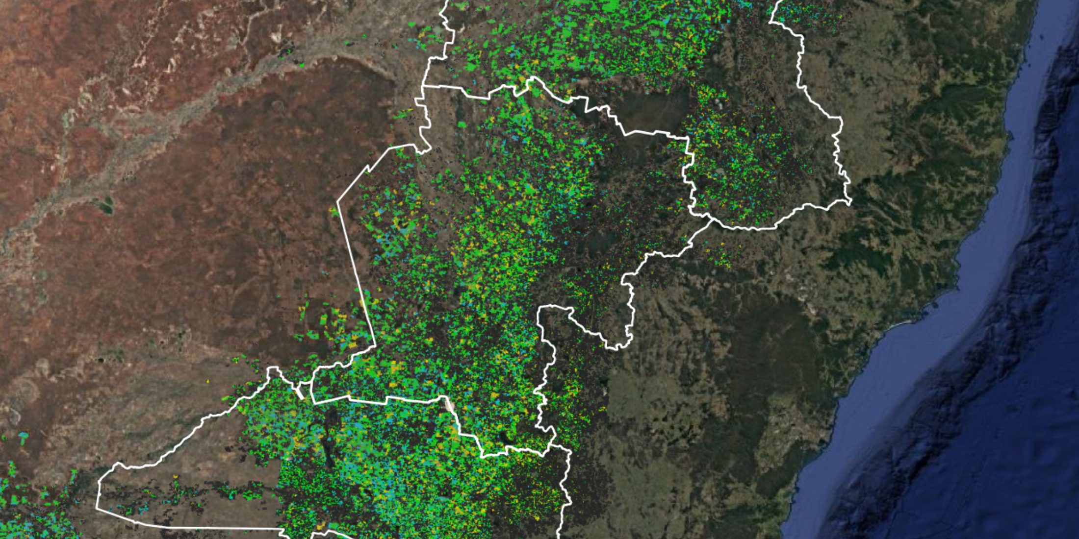
NSW's Renewable Energy Zones (REZs) are a primary driver of the trend. Data centre developers are following energy infrastructure into farming regions, drawn by the reliable and affordable renewable power REZs offer. The three resource management regions outlined contain the NSW REZ corridors which alone account for $2.44 billion of total rural land transaction value recorded in 2025 according to DAS.
Sarah Gorman, Head of Growth and a founding team member at DAS, said:
"Data centres represent important national infrastructure, and the economic opportunity they bring to regional communities is real. But they also represent a new kind of pressure on productive farming land, and the cumulative impact on our food-producing capacity needs to be visible — tracked in near real time."
"At a moment when global supply chains are under pressure and the cost of inputs from fuel to fertiliser can shift overnight, the resilience of our domestic food-producing land base matters more than ever."
Changing land use
As competing demands for food production, renewable energy, digital infrastructure and climate adaptation converge, visibility into land-use change is becoming increasingly important for lenders, insurers, investors, agribusinesses and governments.
DAS identified five regions it considers prime candidates for future data centre activity, all of which have seen elevated land transaction volumes:
- North West NSW NRMR (containing New England REZ): $998.8 million in transactions across more than 708,000 hectares of cropping and grazing land
- Central West NSW NRMR (Central-West Orana REZ): $817.9 million in transactions across more than 785,000 hectares
- Riverina NSW NRMR (South-West REZ, Hay region): $627.1 million in transactions across more than 575,000 hectares of predominantly dryland cropping
- Hume, Victoria: $292.3 million in transactions across more than 15,000 hectares of predominantly pasture-based land
- Melton, Victoria: $4.4 million in transactions across a smaller, urbanising agricultural footprint, representing an earlier-stage transition zone
In addition, DAS intelligence shows the regions targeted are core to Australia's grain supply, with Riverina, North West NSW and Central West each producing more than 4.5 million tonnes of wheat, barley and canola annually on a five-year average basis.
Gorman added:
"For much of the past decade, conversations about risk to Australian agricultural land centred on ownership — who was buying our farmland and whether that concentration posed a risk to food security.
"Then climate risk moved to the centre of that conversation: what acute and chronic pressures — extreme weather events, prolonged drought, shifting growing conditions — mean for what that land can produce, and for the banks, lenders and investors who hold it as collateral. Suddenly the question wasn't just who owns the land, but whether it would keep performing.
"What we're seeing now is a third layer. It's not just who owns the land, or what the climate will do to its productivity — it's what the land is being used for.
"Land use has become as consequential a risk factor as ownership or climate, and it's moving faster than the frameworks designed to manage it.
"DAS operates at the intersection of climate risk, artificial intelligence, spatial finance and rural land. We're building the digital infrastructure that makes rural lending, insurance, investment and policy both viable and climate-aware.
"The ability to discover, visualise and understand what is happening across rural landscapes in near real time is becoming increasingly important. Land-use change, climate exposure, productivity and transaction activity can no longer be managed through assumptions alone.
"DAS provides one of the most comprehensive rural geospatial intelligence platforms across Australia and New Zealand for off-farm discovery, visualisation and decision-making. Tracking what is happening to land — in near real time — is increasingly central to how governments, financial institutions and industry understand and price risk in regional Australia."
.png?width=1274&height=886&name=image%20(313).png)
Image 1: NSW REZ corridor, all pasture paddocks in pink and all crops in orange.
.png?width=1274&height=886&name=image%20(312).png)
Image 2: Crop breakdown by barley, wheat and canola in the NSW REZ corridor.
About DAS
DAS is an agri-fintech company transforming how financial systems and governments locate, finance, insure and invest in rural assets and portfolios. The company is an Australian/New Zealand leader in off-farm decision making, visualisation and discovery.
Its Rural Intelligence Platform™ serves more than 100 organisations — including state and federal governments, the Australian Bureau of Statistics, Rabobank, Ray White Group, IAG, Nutrien and Viterra — integrating intelligence on climate, productivity, sustainability, risk, transactions and land use to help them lend, insure, invest and sell better.
Through DAS Portfolio, the DAS Rural Sales Dashboard and Grain Intelligence, organisations can discover, visualise and understand opportunities and risks across Australia's rural economy using real-world spatial intelligence rather than assumptions.
DAS was recognised in the Deloitte Access Economics Impact of Fintech in Australia report as a company transforming insurance and credit decisions in the agriculture sector, making farmland more insurable, financeable and fairly priced. Its rural-focused geospatial platform represents a step forward in Australia's digital infrastructure, strengthening the nation's capability to support sustainable growth, food security and risk management.
Contact Us
Do you have enquiries about off-farm decision making in Australia and New Zealand? Get in touch with our team.