

In residential markets, address-based geocoding works reasonably well. Properties are tied to street numbers, consistent naming conventions, and dense road networks. A standard address is usually enough to return a usable location.
Rural property is different.
Sales records often reference road names without street numbers, paddock or station names, or incomplete address fields. In many cases, the only reliable identifier is a lot and plan number. This creates a core issue in rural property valuation and pricing.
A coordinate can indicate where something might be. It does not confirm what the property is, where its boundaries sit, or whether the sale has been correctly linked to the underlying asset. When applied to rural property pricing, this leads to mislocated sales and unreliable comparables.
If the underlying sale is wrong, every downstream metric is affected. Price per hectare, comparable sales, market trends and valuation inputs all rely on spatial accuracy.
This is where DAS takes a different approach.
Rather than relying on address-based geocoding alone, DAS anchors rural sales to the cadastre, the official government record of land parcels. This ensures that sales are linked to the correct property, not an approximate location.
This shifts the unit of analysis from a point to a boundary.
In cases where a record contains only a road name and no coordinates, this approach still resolves the correct parcel. The result is the full spatial extent of the property, including its size and shape.
Why this matters for rural property pricing
Rural properties can span hundreds or thousands of hectares. Small errors in location can result in large differences in land characteristics, productivity, rainfall exposure and value. A point placed even a few kilometres away may represent a completely different asset.
Using this approach allows DAS to:
- Resolve rural property sales with incomplete or inconsistent location data
- Return full property boundaries instead of approximate locations
- Maintain consistency across different land title systems in Australia
- Support more reliable comparable sales analysis
How this supports comparable sales
When agents, valuers or lenders assess comparable sales, they rely on the assumption that the data is correct. That the sale reflects the actual property being analysed.
Without that, comparisons break down. That's why geospatial validation should always be the starting point for reliable rural property data.
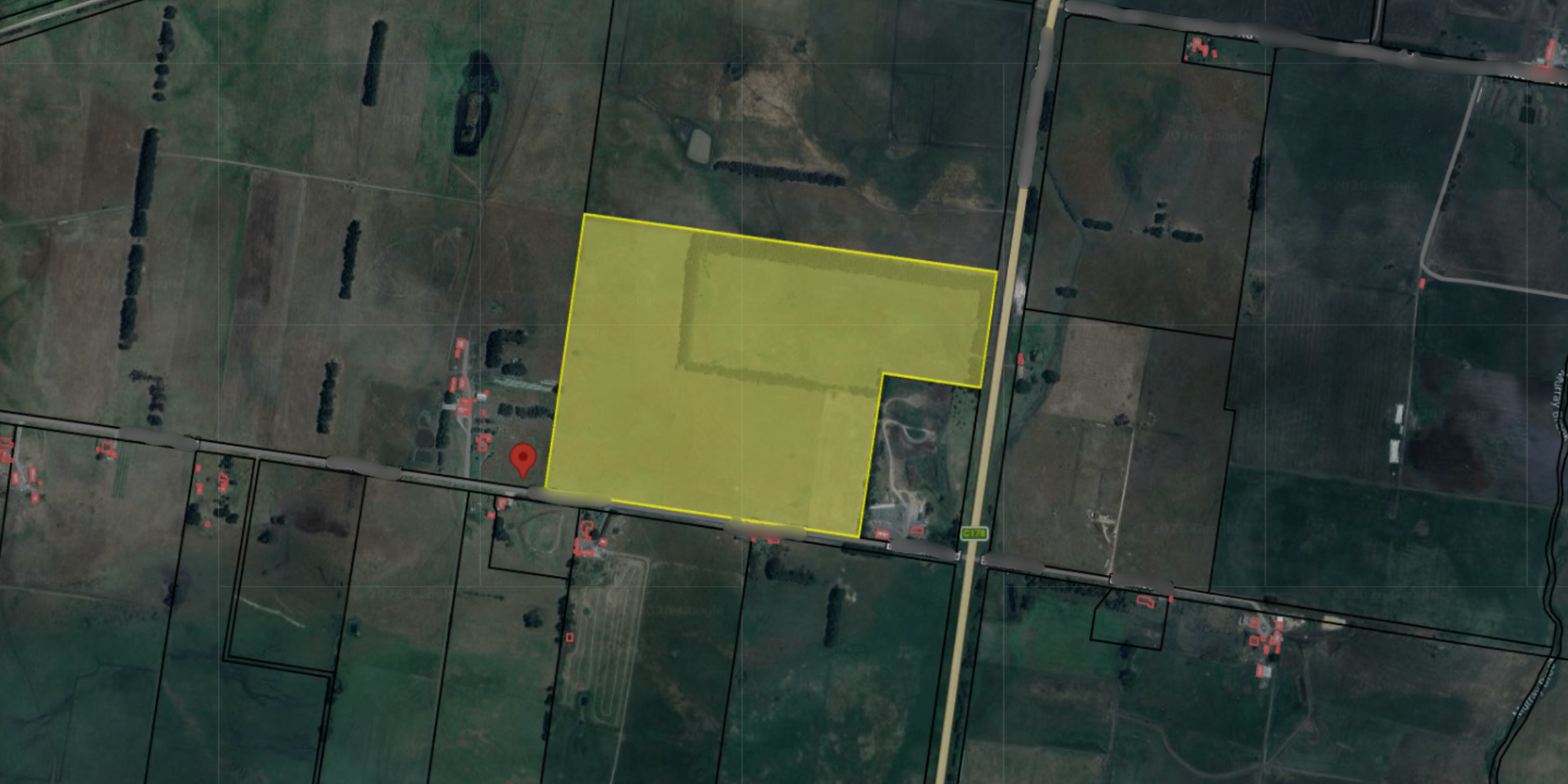
See a recent example
A recent sales record arrived to DAS with no latitude or longitude, and only a road name in the address field. On that basis alone, there is no reliable way to pinpoint the property. A geocoder would either fail or return to an arbitrary point somewhere along the road.
What the record did include was a legal description.
Using this reference, DAS resolved the correct parcel and returned the full boundary of a 32.19 hectare property. The parcel was accurately mapped and correctly attributed (see image below).

Get in touch with DAS to improve your rural property data
To access validated rural property data and comparable sales, get in touch with our team
Frequently asked questions about Australian Rural Property
How do you accurately value rural property?
Accurate rural property valuation depends on more than comparable sales. It requires reliable spatial data, correct parcel attribution, and an understanding of land capability, productivity, water access and climate exposure.
Why is rural property harder to value than residential property?
Residential properties are generally uniform and easier to compare. Rural properties vary significantly in size, land use, productivity and environmental conditions. Small differences in location can materially affect value.
What is geospatial validation in rural property data?
Geospatial validation is the process of confirming that a sales record matches the correct parcel of land. This helps ensure that comparable sales, price per hectare metrics and valuation analysis are based on the correct property.
Why is address-based geocoding unreliable for rural property?
Many rural sales records contain incomplete addresses, road names only, or no usable coordinates at all. Traditional geocoding methods can return approximate or incorrect locations, which creates errors in pricing and comparable sales analysis.
What is cadastral data?
Cadastral data is the official government record of land parcels and boundaries. It defines the legal extent and ownership structure of property and is critical for accurately locating rural assets.
How does DAS locate rural property sales?
DAS uses cadastral data to validate and spatially resolve rural property sales. This allows sales records to be linked to the correct parcel boundary rather than an approximate coordinate.
Why does accurate location data matter for rural property pricing?
Rural properties can span hundreds or thousands of hectares. A small location error can result in significant differences in rainfall, soil, land capability or productivity, all of which influence value.
How does geospatial validation improve comparable sales analysis?
Comparable sales analysis depends on accurate property attribution. Geospatial validation helps ensure the sale being analysed reflects the actual property, improving the reliability of pricing, valuation and lending assessments.
Who uses validated rural property data?
Validated rural property data supports agents, valuers, lenders, insurers and investors who rely on accurate comparable sales and property intelligence to make decisions.