

Grain Intelligence is a DAS product that delivers in-season crop estimate reports and tailored data products. Over the past 12 months, the DAS team has been developing a new paddock boundary dataset for Grain Intelligence to improve paddock-level accuracy.
The DAS Earth Observations team, who lead the charge with delivering Grain Intelligence to clients, created the new paddock boundary dataset using the latest, state-of-the-art Machine Learning methodologies.
The formation of the data set has captured significant land changes in areas of New South Wales, Victoria and South Australia that were impacted by drought in 2019. With many paddocks fallowed in these areas, analyses on multiple real paddocks presented themselves as single paddocks. In those cases, DAS classified for a single crop type across that ‘paddock’ and introduced a source of error into crop estimates.
“These errors didn’t lead to over or under estimation of crop areas at regional scales, but it was a major source of error at the paddock scale. Our new paddock boundary dataset significantly reduces this source of error and is another incremental improvement to our Grain Intelligence product suite,” said Sam Atkinson, Earth Observations Lead at DAS.
As a result, the DAS team has successfully mapped 1,622,329 paddocks, of which 969,889 are routinely cropped.
“Our team has shown fantastic initiative by creating this data set over the past year, it provides additional value for our Grain Intelligence clients and any organisations that take interest in crop monitoring at a paddock level, not only in the winter growing season, but also the summer growing season which is a recent expansion of our Grain Intelligence offering,” said Anthony Willmott, CEO and Co-Founder at DAS.
How does the new paddock boundary data benefit the Ag industry?
Does your organisation care about what is growing at a paddock level? Do you need up-to-date paddock boundaries for your application?
DAS’ paddock boundary data provides previously unmatched precision for paddocks based on the current state of the land—not land that was previously impacted by drought.
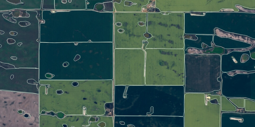
The new paddock boundary dataset from DAS provides improved delineation of non-arable features within paddocks such as; dams, roadways, patches of trees and creeks. This improves exclusion of non-arable parts of paddocks from area measurement, thus providing more accurate and detailed results.
The new paddock data product is now available from DAS
Organisations that want to access the paddock data can enquire via the form below.
If you wish to see what is growing within paddocks, or what has grown in those paddocks over previous years, you can also enquire about receiving DAS’ Grain Intelligence data. Grain Intelligence data is available for the winter and summer growing seasons.
If you would like to know more about accessing the paddock boundary data or Grain Intelligence data, speak with our team by filling out the form below.