

New analysis from DAS (Digital Agriculture Services) using Australia's leading DAS Climate Datasets has uncovered a harsh reality: large swathes of South Australia and south-western Victoria are enduring their worst consecutive years of rainfall for grain farming since 1970.
This analysis, conducted for DAS' new report Mapping Climate Risk: A Data-Driven Guide to Rural Property Risk, Resilience, and Opportunity, is just an example of the type of analyses that can be performed with DAS' industry-leading Climate Datasets.
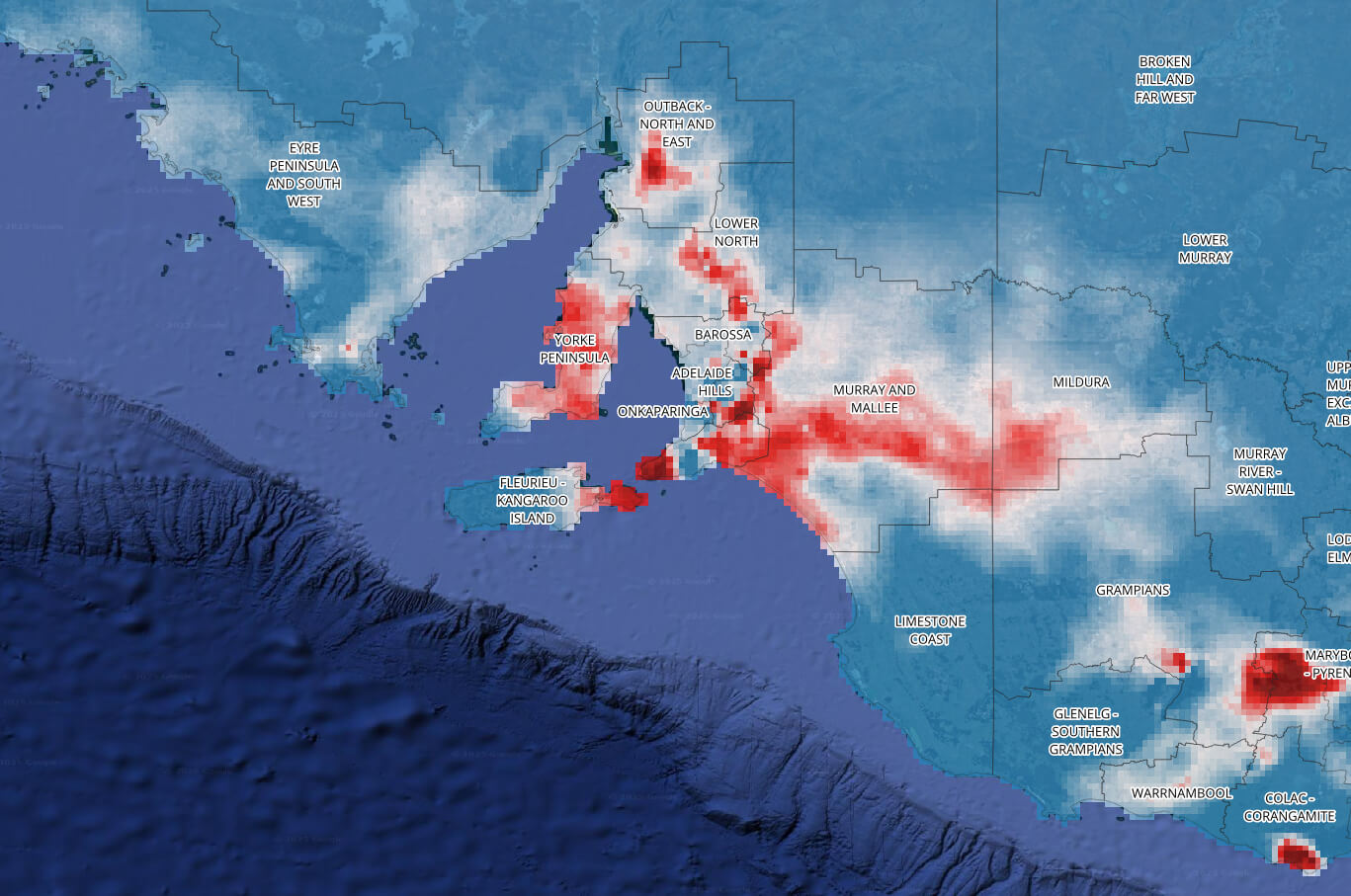
What the DAS Climate Data Shows For The Current Drought Conditions in SA and VIC
This particular analysis using the DAS Climate data combines:
- Last year’s growing season rainfall (June to September 2024) with;
- This year’s planting season rainfall (February to May 2025).
It then compares this combined total to the lowest rainfall recorded for the same months in any year since 1970. The map produced from this analysis shows:
- Blue areas are receiving at least 100mm more rainfall than the lowest on record.
- White areas are matching the driest periods in the past 54 years.
- Red areas are worse than anything recorded since 1970, a devastating new low.

Where Conditions Are Worst
These red zones in the above map show where rainfall is at historic lows, these areas include some of Australia’s most important agricultural regions:
- Murray and Mallee
- Barossa
- Adelaide Hills
- Yorke Peninsula
- Mid North and Lower North
- Mildura
- Grampians
- Maryborough – Pyrenees
- Colac – Corangamite
- Glenelg – Southern Grampians
This second DAS map adds a critical layer of insight: it shows actual winter broad-acre cropping paddocks (in black) overlaid on these rainfall zones.

The reality is confronting, many of the regions suffering the worst rainfall on record are also the most intensively cropped.
This means farmers have sown winter crops into the driest soils seen in over five decades, even drier than during the Millennium Drought or 1982’s record dry.
What other analysis is contained within the report?
While past climate models have focused on broad regional averages, DAS’ Climate Data enables users to drill down to rural property-level resolution, revealing hidden vulnerabilities in farm operations and enabling targeted, evidence-based responses across the agricultural value chain.
The report features two further detailed case studies, like the one above, that challenge long-held assumptions about climate exposure.
Southern Cross, WA: The Myth of Stability
Despite having stable average rainfall totals, Southern Cross is undergoing a critical shift: winter rainfall is in decline, while summer rainfall is rising. This seasonal redistribution threatens the viability of winter cropping systems—and highlights the limits of relying on annual averages to assess risk. DAS analysis reveals and proves this seasonal rainfall transition, and explores how various stakeholders in the grain industry can respond to the shift.
Walgett, NSW: Climate Risk at Both Region & PropertyLevel
Walgett, NSW—a key cropping region—has experienced a measurable long-term decline in annual rainfall since 1970. But the real breakthrough comes from DAS’s ability to analyse risk down to property level. In the report, DAS explores how rainfall deficits and drought severity impact a farm in this region. Granular views, like that provided in this example, are already being used by DAS clients to restructure loan products and design targeted insurance cover.
Data That Changes the Climate Conversation
As Australia’s farming regions confront increasingly erratic and extreme climate conditions, the need for precise, localised, and actionable data has never been more urgent. DAS’s latest analysis shows just how transformative that data can be—from exposing current drought conditions in some of the country’s most intensively cropped zones, to revealing long-term rainfall shifts and farm-level drought stress.
This is more than just a snapshot of current conditions—it’s a blueprint for the future of climate-smart agriculture.
Download the full report—Mapping Climate Risk: A Data-Driven Guide to Rural Property Risk, Resilience, and Opportunity—to explore the findings, understand the risks, and learn how data-driven insights can support more resilient decision-making from paddock to portfolio.
DOWNLOAD YOUR FREE COPY